Aviation Weather: AWOS, ASOS and ATIS. What's the difference?
As we enter the spring and summer months here in the Midwest, I know many fellow pilots are undoubtedly gearing up for some much-anticipated flying. And while we all love clear skies and calm weather, we know that mother nature can be unpredictable at times. That's why it's essential to stay informed and prepared when it comes to weather planning. Be sure keep up-to-date on the latest conditions and forecasts, so you can make informed decisions about when and where to fly. And if conditions change unexpectedly, be ready to adjust your plans and stay safe in the air.
In this blog post, I will focus on some of the aviation weather services available to pilots as a refresher for some who haven’t flown in a while or are new to flying. My focus will be on the alphabet soup of aviation weather reporting systems that pilots should be familiar with, particularly, AWOS, ASOS, and ATIS. I will cover ADS-B and other weather topics in a subsequent blog.
Weather is a one of the most critical factors that a pilot must take it into account before every flight. Weather can affect all aspect of a flight, from takeoff and landing to cruise altitude and route selection. Hazards such as turbulence, icing, thunderstorms, and reduced visibility can pose serious risks to the flight. Pilots need to have accurate and up-to-date weather information to make informed decisions about their flight plans, routes, altitudes, and aircraft performance.
Aviation weather services are essential for pilots to safely operate their aircraft in different weather conditions. There are several types of services available to pilots, including the Terminal Aerodrome Forecast (TAF), which provides information about expected weather conditions at a specific airport; the METAR (Meteorological Terminal Aviation Routine Weather Report), which gives current weather information at an airport; and the Area Forecast (FA), which covers a larger region and provides information on weather trends and conditions. Additionally, pilots can access weather radar data, satellite images, and other weather products through services like Flight Service, Aviation Weather Center (AWC), and the National Oceanic and Atmospheric Administration (NOAA). It is crucial for pilots to be aware of and utilize these different services to make informed decisions about their flights and ensure the safety of their passengers and crew.
AWOS, ASOS, and ATIS are automated weather information systems used in aviation to provide pilots with accurate and timely weather information. However, there are differences between these systems in terms of their capabilities and the information they provide.
AWOS (Automated Weather Observing System) is a weather station that automatically measures and reports current weather conditions, including wind speed and direction, temperature, dew point, visibility, cloud height, and precipitation. AWOS can provide pilots with real-time weather information and is often installed at smaller airports and airfields.
ASOS (Automated Surface Observing System) is a more advanced version of AWOS and provides pilots with more detailed and comprehensive weather information. In addition to the parameters measured by AWOS, ASOS can also report on pressure, altimeter setting, and other meteorological data. ASOS is typically installed at larger airports and can provide pilots with more accurate and reliable weather data.
ATIS (Automatic Terminal Information Service) is a recorded message that provides pilots with updated weather information for a particular airport or terminal area. ATIS includes information such as wind direction and speed, temperature, dew point, visibility, cloud cover, and runway information. Pilots must listen to the ATIS message before landing at an airport to get the latest weather information and adjust their approach and landing accordingly.
In addition to AWOS, ASOS, and ATIS, pilots should rely on other sources for weather information and planning to ensure they have a comprehensive understanding of the weather conditions affecting their flight. These sources include:
-
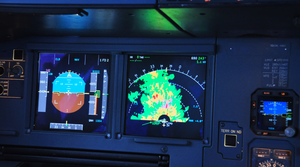
Weather Radar: XM Weather and NEXRAD can provide information on precipitation, storms, and other weather conditions in the area, however pilots my remember that there is a delay with NEXRAD, so what you see on the screen will not necessarily reflect what you see outside. A major step up from NEXRAD is On-board Radar. On-board Radar will provide immediate picture of what's happening real-time out your window. NEXRAD and on-boar radar should be used together for strategic and tactical hazardous weather avoidance while flying.
-
Aviation Weather Center (AWC): The AWC provides pilots with weather forecasts, charts, and data, including graphical and textual weather products. These products can help pilots plan their flights, monitor changing weather conditions, and make informed decisions during their flights.
-
Flight Service: Flight Service provides pilots with weather briefings, including updated weather information, forecasts, and advisories. Pilots can use this information to plan their flights, route, and altitude.
-
National Oceanic and Atmospheric Administration (NOAA): NOAA provides weather forecasts, satellite images, and other weather products that pilots can use to plan their flights and monitor weather conditions.
-
In-Flight Weather Reports: En Route Flight Advisory Service (EFAS or Flight Watch) provides timely en route weather information to pilots upon request. EFAS can be one of the best sources for current weather information along the route of flight. The common EFAS frequency, 122.0 MHz, is established for pilots of aircraft flying between 5,000 feet above ground level (AGL) and 17,500 feet mean sea level (MSL). In addition to EFAS, pilots can also receive weather reports from other pilots who are currently flying in the same area through PIREPs. This information can be helpful in identifying changing weather conditions and hazards.
Pilots should rely on a variety of sources for weather planning to ensure they have a comprehensive understanding of the weather conditions affecting their flight.
In recent years, there have been many general aviation accidents caused by poor weather planning or inadequate weather information. Some no too distant examples of G/A accidents caused by poor weather planning or inadequate weather information include:
-
Cessna 182: In November 2018, a Cessna 182 crashed in California, killing the pilot and two passengers. The aircraft encountered icing conditions and was unable to maintain altitude. The pilot had not obtained a weather briefing before the flight. (NTSB report LAX19FA019)
-
Cirrus SR22: In December 2018, a Cirrus SR22 crashed in Indiana, killing the pilot and two passengers. The aircraft encountered icing conditions and lost control. The pilot had not obtained a weather briefing before the flight. (NTSB report CEN19FA055)
-
Piper PA-32: In March 2019, a Piper PA-32 crashed in North Carolina, killing the pilot and two passengers. The aircraft encountered severe turbulence and broke apart in flight. The pilot had not obtained a weather briefing before the flight. (NTSB report ERA19FA160)
-
Cessna 182: In August 2019, a Cessna 182 crashed in Arizona, killing the pilot and one passenger. The aircraft encountered severe turbulence and was unable to maintain altitude. The pilot had not obtained a weather briefing before the flight. (NTSB report WPR19FA266)
-
Beechcraft Bonanza: In October 2019, a Beechcraft Bonanza crashed in Louisiana, killing the pilot and two passengers. The aircraft encountered thunderstorm activity and lost control. The pilot had not obtained a weather briefing before the flight. (NTSB report CEN20FA042)
In all of these accidents, poor weather planning and inadequate weather information were contributing factors. It is worth noting that these accidents are just a few examples of the importance of weather planning in general aviation, and there have been many more incidents and accidents with similar contributing factors. Pilots should always prioritize safety and take weather planning seriously to help ensure the safe and efficient operation of their flights. Pilots should be prepared to adjust their flight plans and decisions based on changing weather conditions. Pilots should also prioritize safety over other considerations, such as schedules and personal preferences, and seek assistance from aviation weather experts and air traffic controllers when needed. Finally, pilots should ensure they are qualified and properly trained to fly in different weather conditions, and they should maintain their skills and knowledge through ongoing training and education.
Thank you for reading the blog, fellow pilot and aviation enthusiasts! As we wrap-up, remember that weather planning is essential for safe and successful flying. Even though we're all eager to take advantage of the spring and summer skies, it's crucial to stay aware of changing weather patterns and be ready to adapt as needed. Whether you're a seasoned pilot or just starting out, don't underestimate the importance of weather planning. Stay tuned to the latest weather updates and analysis, and make informed decisions about your flights based on the conditions you see. By prioritizing safety and staying informed, we can all enjoy the beauty and wonder of flight without putting ourselves or our passengers at risk. So, until next time, happy flying!